Silver Island Mountains
- Alex Cabrero
- Jun 29, 2025
- 5 min read
Updated: Nov 22, 2025

(Wendover) Sometimes, the best adventures are the ones that don’t even require getting out of your vehicle. It can be you, your dog, and cruising in your Jeep on dusty dirt roads through a place that feels like the edge of the world. Windows down, ears flapping, tires kicking up dust, and time stretching out like the desert horizon in front of you.

This was one of those drives.

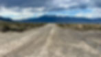
The Silver Island Mountains Backcountry Byway is a 54-mile gravel and dirt road loop that wraps around a rugged, lonely mountain range just outside of Wendover. It's very easy to reach just off I-80. The Bonneville Salt Flats are nearby and there's a good chance you'll have this drive all to yourself. The feeling of isolation is so thick you could bottle it up and sell it to introverts.

Timber and I did this drive in the early Spring of 2024. It's one I had looked at doing for several years. I had been to the Salt Flats several times before, but I had never ventured further out and onto the loop. So, I asked Timber if she wanted to go "Jeep" and she was pretty much in the back seat before I finished the word. I didn't know it at the time, but Timber was only five months from passing away from liver cancer. The awful disease might've already started in her liver at the time of this drive and there was no way to know. She certainly didn't act any different. It makes me cherish this trip even more and it's a place that will always be special to me.

We headed out with a tank full of gas, snacks, water, and zero expectations. That’s often the best way to approach places like this. You get off Exit 4 on I-80 near Wendover and go about a mile or so to where the pavement ends and the wild begins. As you get to the dirt road and start heading north, you'll see old-looking jagged rocky peaks to your left and salty silence to your right. You could do this lop either way, but personally, I think going counter-clockwise is the best. To me, the views are better this way. We slowly worked our way along the byway, bouncing down the road and soaking in the desolate beauty of it all.
Near the top of the loop, just before it starts to curve back south, you'll see a marker sign for the Hastings Cutoff. This is a quiet, powerful, and tragic piece of American West history. This is the infamous shortcut the Donner Party took in 1846, thinking it would save them time on their way to California. Unfortunately, it didn't. The same route that promised pioneers a faster path west ended up costing many of them their lives.

The Hastings Cutoff is a great spot to turn off your car, get out, and just stare at the flat expanse in front of you. It's so quiet, you can hear nothing and everything all at once. If you look out away from the dirt road a bit, you can see the faint wagon ruts still pressed into the desert and carved into time. Knowing the Donner Party story, and seeing the land they were about to travel, it's an eerie, humbling, and powerful feeling that's tough to describe. These weren’t tourists with GPS and foam cups full of water and ice. These were people pushing through the unknown in wooden wagons, hoping their gamble would pay off. Unfortunately, it didn't.

There's also a shortcut toward the middle of the loop so you can make the trip quicker. I decided to do the whole loop and save the shortcut for the next time I visit so I can see something different. If you have enough time, I say go for the whole loop.

I love to geocache and there are some geocaches out there. I found two of them, but cell service can be a bit tricky on the Byway, so maybe download a couple of off-line maps beforehand.

The Silver Island Mountains aren’t flashy. You probably won't find them in any tourism brochures or on bucket lists. But, to me, they’re quietly incredible. They offer the kind of beauty that sneaks up on you in silence, as if they're been waiting for you. It feels like time here stands still.
Bring a lunch. Take your time. Stop every now and then to just ponder. And if you’re lucky, like I was, you’ll share that silence with a good dog sticking her head out the window taking in the same views pioneers once saw. Unlike them, though, you can get back in your car and blast the air conditioning to continue your trip :)

After a solid three to four hours of slow driving and getting out to take pictures and hear silence (we don't hear silence enough these days), Timber and I finished the loop and make our way back toward I-80. There's a gas station there to get more snacks and cold drinks.

After a nice long day exploring, Timber and I rented a camping cabin at the KOA Campgrounds in Wendover. I love these camping cabins. No running water or bathrooms (there's a communal place for those), but these little wooden cabins have a roof, porch, porch swing, and bed. You'll have to bring your own blankets and pillows, but seriously, these cabins are great. Timber loved them, too, and always slept by my feet hoping there's another adventure tomorrow.

LOCATION OF THE START OF THE LOOP:
Google Map Link TIPS FOR THE LOOP:
-You don't really need a 4-wheel drive. The road is smooth enough for regular cars. Some people do the loop on motorcycles and bicycles. Just be careful if it has rained recently. You could get stuck out there.
-Make sure you have water, snacks, a full tank of gas (that gas station off Exit 4 is a great place to fill up on everything), maybe even a spare tire. You probably won’t need them. Until you do.
-Cell signal might be tough and you may not see anyone else all day. Let someone know your plan.
-Be careful driving on mud flats or salt flats. They look firm, but again, if it rained recently, it's easy to get stuck and a tow truck out of Wendover is expensive.


